


1. INTRODUCTION
Covid-19 began on December 8, 2019, in Wuhan, China, and was officially declared a “worldwide pandemic” by the World Health Organization (WHO) on March 12, 2020. Many countries strengthened their containment policies, causing the aviation industry to suffer. While domestic airlines were trying to minimize damage, such as self-rescue efforts and government support, the aviation industry faced a massive crisis as Russia unexpectedly invaded Ukraine on February 24, 2022.
It is the implementation of active political, economic, and international sanctions, such as the prohibition of entry into Russian airspace and territorial waters. On February 28, 2022, the European Union (EU) announced that it would close its airspace against Russia, and Korean Air decided on March 15, 2022, to operate Europe and the US Eastern departure routes to avoid Russian airspace for safety. As a result, the average flight time for the passengers increased significantly, and the fuel costs increased, which caused the inevitable shrink of global air route operations. Recently, in Korea, it became a social issue that the sixth industrial accident was recognized due to the space radiation exposure of a flight attendant. And inevitably, increased flight time and latitude changes due to the Russia-Ukraine war might cause the unexpected radiation exposure increase. So we decided to analyze whether these concerns are valid or not quantitively.
In this study, we compared and analyzed the exposure dose change of space radiation according to the Russia detour route by using a space radiation prediction program for eight air routes; four in the eastern United States and four in Europe. Finally, we found how the detour route affects the radiation exposure, flight time, and latitude of space radiation. We expect that these results can contribute to the establishment of policies for the safety management of space radiation for aircrews and passengers.
2. DATA
Table 1 shows the statistics of flight numbers to the eastern United States from Incheon to New York, Chicago, Washington, and Boston from 2019 to 2021 for three years. Due to covid-19, it has been confirmed that there exist apparent changes in flight numbers, but they are not so significant. Instead, the increase in some routes could be attributed to the increase in cargo flights rather than passenger flights. As shown in Table 2, there was no significant difference in flights operated on US eastern routes after the Ukraine war occurred in March 2022.
| Year | New York | Chicago | Washington | Boston |
|---|---|---|---|---|
| 2019 | 3,109 | 1,974 | 730 | 365 |
| 2020 | 3,240 | 2,479 | 417 | 209 |
| 2021 | 3,426 | 3,541 | 418 | 313 |
| Time | New York | Chicago | Washington | Boston |
|---|---|---|---|---|
| January 2022 | 298 | 259 | 44 | 27 |
| February 2022 | 252 | 240 | 44 | 24 |
| April 2022 | 244 | 245 | 37 | 26 |
| May 2022 | 258 | 256 | 35 | 26 |
In the last three years, major air routes for Europe have changed significantly due to covid-19. Unlike the US eastern routes, the number of passenger flights has decreased noticeably, as shown in Table 3. However, in the case of Frankfurt Airport, operating both passenger and cargo planes, the number of flights has increased because of increased cargo flights. On the other hand, in cases of the other flights for Amsterdam, Paris, and London have decreased due to covid-19. But for the effect of war, there was no significant difference in the changes of the four European routes after the Ukrainian war in March 2022—the trend of increasing passenger planes as the covid-19 period is ending, as shown in Table 4.
| Year | Frankfurt | Amsterdam | Paris | London |
|---|---|---|---|---|
| 2019 | 4,144 | 1,227 | 2,173 | 2,342 |
| 2020 | 3,612 | 1,024 | 913 | 1,209 |
| 2021 | 4,064 | 993 | 653 | 804 |
| Time | Frankfurt | Amsterdam | Paris | London |
|---|---|---|---|---|
| January 2022 | 310 | 80 | 55 | 71 |
| February 2022 | 269 | 70 | 46 | 62 |
| April 2022 | 363 | 70 | 53 | 82 |
| May 2022 | 386 | 71 | 61 | 79 |
To compare and analyze the direct effect of the Russian detour routes after the war in Ukraine, the flight time and highest flight latitude for the routes departing from the eastern United States (New York, Chicago, Washington, and Boston) were analyzed based on the flight plans. The data we used are flights in April 2021 and April 2022 obtained from Korean Air. Flights from New York are 19 flights in 2021 and 28 flights in 2022, and flights from Chicago are 19 flights in both years. Flights from Washington are 15 flights in 2021 and 17 flights in 2022; those from Boston are 13 flights in both years. The average flight time and the highest latitudes are summarized in Table 5.
From Table 5, we found that before the war in 2021, the North Pole and Russian routes were operated over 70 degrees north, whereas after the war in 2022, all flights were flying below 70 degrees north to avoid flying over Russian airspace. And this latitude change in the air route resulted in a net increase in flight time. As a result of comparing the average flight time, the difference in flight time before and after the Russian detour route was up to 1 hour and 20 minutes for flights departing from Boston and at least 42 minutes for flights departing from Chicago.
Similarly, we analyzed the geographic information of flight plans of European departure routes for Frankfurt, Amsterdam, Paris, and London after the war. The flights from Frankfurt are 15 flights in 2021 and 17 flights in 2022; from Amsterdam are five flights and eight flights; from Paris are nine flights in both years; and from London are 12 flights and 19 flights. The average flight time and average latitude are shown in Table 6.
There is a clear difference between the European and eastern US routes. The European route initially flew through Russian airspace for a long time, but they could not pass through Russian airspace after war; the latitude of the Europe airport is the highest on the route, and the flight time became longer. According to the above analysis results, the average flight time between flying Russian routes before and after the war they were increased by up to 1 hour 37 minutes from Amsterdam and at least 1 hour 8 minutes from Frankfurt.
3. COMPARATIVE ANALYSIS OF EXPOSURE DOSES ON SIGNIFICANT ROUTES
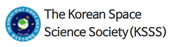
In the universe, various radiations are flying toward the earth, collectively referred to as cosmic radiation. This cosmic radiation is divided into the Galactic Cosmic Rays (GCR) starting from the galaxy and the Solar Cosmic Rays (SCR) beginning from the sun. GCR pours from distant galaxies, such as supernova explosions, and SCR is caused by solar proton events. When the exposure dose is analyzed at an altitude of 9 to 12 km, which is the cruising altitude of a commercial aircraft, cosmic radiation varies greatly depending on the altitude and the solar activity, especially in the polar region. In contrast, in the equatorial region, the dependence on altitude and solar activity is relatively very weak compared to the polar region (KOFONS 2018).
Fig. 1 shows that the dose rate change of cosmic radiation increases as the flight altitude increases, latitude increases (polar and equator), and solar activity is low (solar minimum and solar maximum). In an aircraft altitude, lowering the altitude by 600 m (2,000 ft) has an average reduction of 13.2% compared to the exposure dose received at that altitude (Ahn et al. 2020). Ambient does an equivalent rate of cosmic radiation during the solar minimum changes from 4.8 to 9 µSv/hr in the polar region, but it changes from 1.2 to 1.7 µSv/hr in the equator region. During the solar maximum, it changes from 3 to 4.9 µSv/hr in the polar region and from 1.5 to 2 µSv/hr in the equator region (Kim 2022). In 2021, the Ministry of Land, Infrastructure, and Transport (MLTM) revised the space radiation safety management regulations for crew members. It stipulated that the annual accumulation dose for aircrew should not exceed six mSv (Korea Law Information Center 2016).
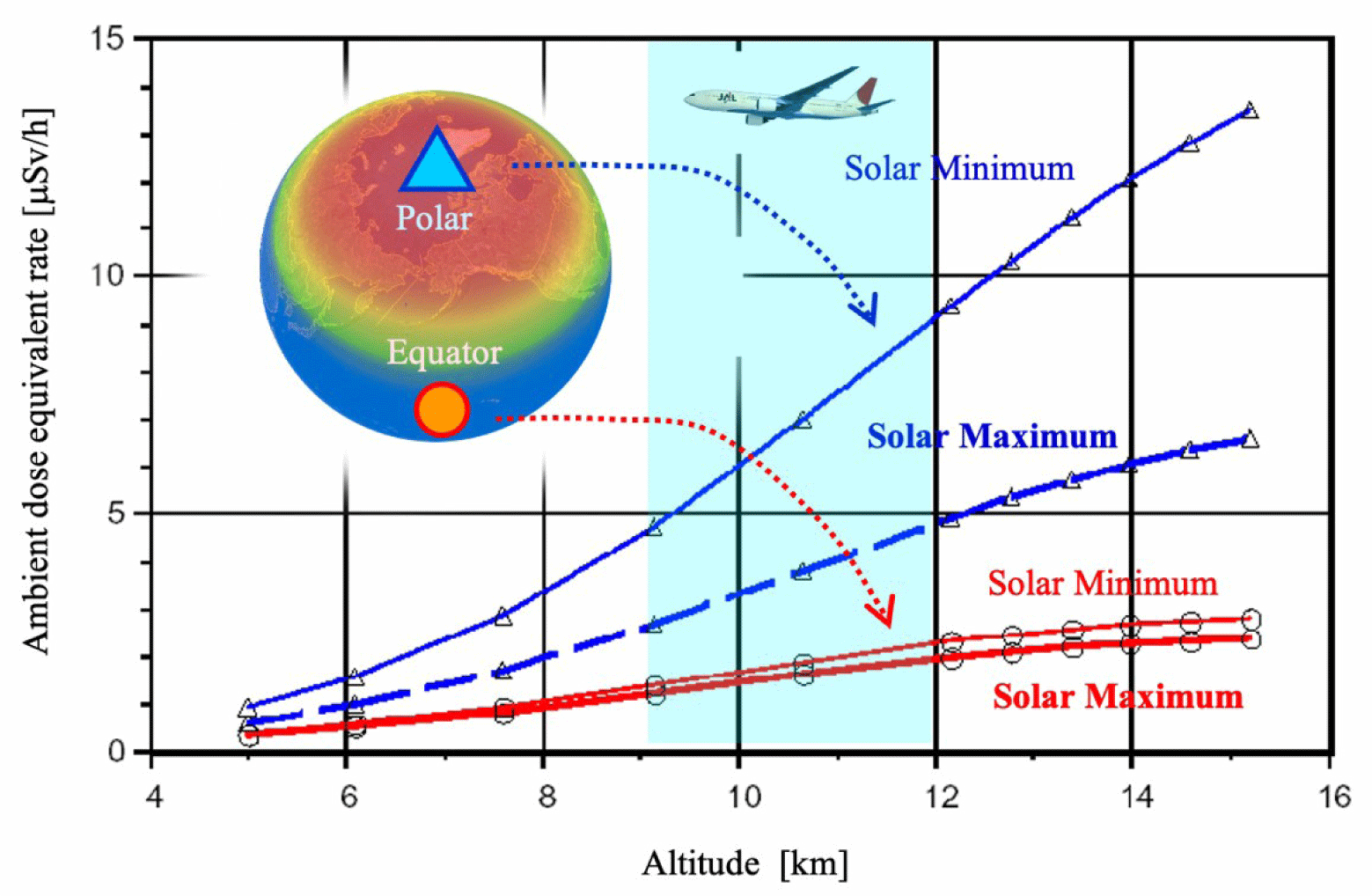
The Korean Radiation Exposure Assessment Model for aviation route dose (KREAM) is a radiation exposure dose prediction model jointly developed by the Korea Astronomical Research Institute (KASI) and the Korea Meteorological Administration (KMA). Recently the KREAM webpage has been opened to the public, and one can calculate his radiation exposure per flight. The radiation calculation page of the KREAM homepage is shown in Fig. 2. KREAM is an original model that reflects not only GCR but also solar proton event effects from the sun and is an improved model that can reflect real-time space weather using the geosynchronous proton data (KMA 2015). KREAM is an enhanced model from previous models such as CARI-6 and NAIRAS because it can include instantaneous space weather changes within a short update period of about 5 minutes for proton observations by geosynchronous satellites (Hwang et al. 2010, 2014, 2020). All comparisons of exposure doses in the air routes in this study utilized the values calculated by KREAM.
CARI-6/6M was developed by Federal Aviation Administration (FAA) Civil Aerospace Medical Institute (CAMI) and is a program that calculates an effective dose rate using the heliocentric potential (HCP) values (O’Brien et al. 2005). CARI-6/6M calculates radiation dose using flight date, departure, and arrival airports, and route information (altitude, flight time). Currently, air carriers can select and use the cosmic radiation exposure radiation dose evaluation program according to Chapter 5 of the Safety Guidelines for Safety Management of Radiation in the Living Environment. Four airlines, Korean Air, Asiana, Jeju Air, and Jin Air, use CARI-6M, while five airlines, Air Busan, Air Seoul, Air Incheon, T-way, and Fly Gangwon, use CARI-6 to evaluate the exposure dose of their flight attendants (KINS 2022). In this study, a comparison of CARI-6/6M exposure dose was not studied. Instead, we use the model which is most recently developed.
Fig. 3 shows the comparative analysis of the average monthly exposure dose before and after using the Russian bypass route caused by the Ukrainian war on four routes in the eastern United States and four routes in Europe between September 2021 and September 2022. Although the flight path was based on the path and altitude of the flight plan, there can be some path and altitude differences for actual flights, but errors are negligible. We found that there are significant diminishing of radiation exposure after the war, which is due to the usage of the Russian detour route. And this tendency is more noticeable for the European routes than the US eastern routes.
Table 7 shows a comparison of the average monthly exposure dose of the normal routes (in September 2021) and the North Pacific route (in September 2022). The normal route various routes such as the Arctic route, Russian route, and North Pacific route. The decrease in exposure dose due to the bypass route was in the largest order of Chicago (11.39 μSv), New York (10.51 μSv), Washington (7.33 μSv), and Boston (2.64 μSv). This seems to be because the exposure dose was calculated low according to the low latitude in the bypass route. The bypass routes are usually 13 to 16 degrees lower than the normal routes.
Four European routes also showed a decrease in exposure dose on bypass routes, as shown in Table 8. The difference between each route was analyzed in the largest order of Frankfurt (22.15 μSv), Paris (19.75 μSv), London (18.2 μSv), and Amsterdam (14.82 μSv). Compared to the US eastern route, it is clearer the radiation exposure dose was diminished due to the bypass route. This might be due to the fact that the bypass route flew at a low latitude of fewer than 50 degrees north, although the flight time increased compared to the usual route that passed for a long time at a high altitude of more than 50 degrees north. The latitude change has more significant effect than the flight time.
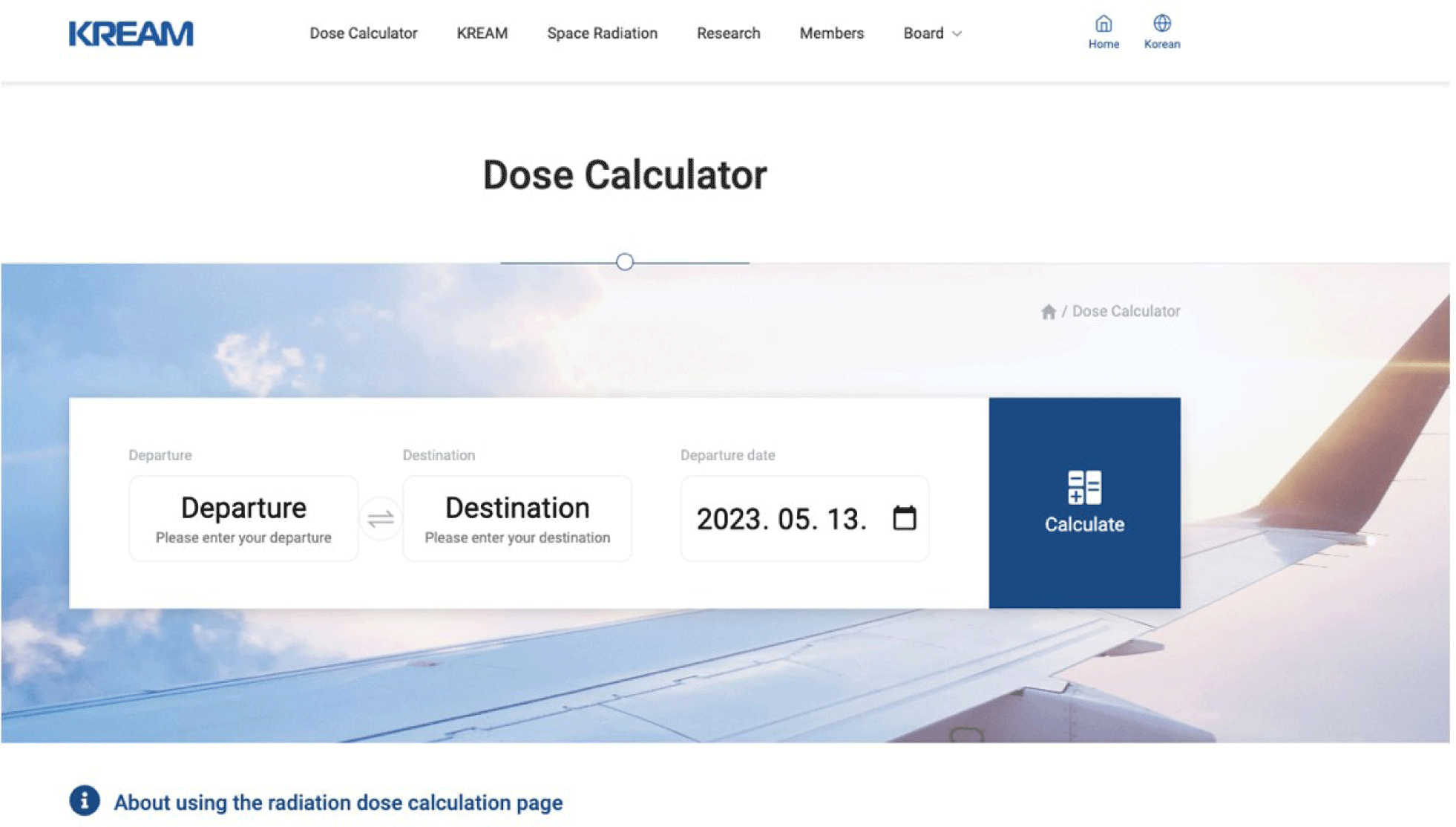
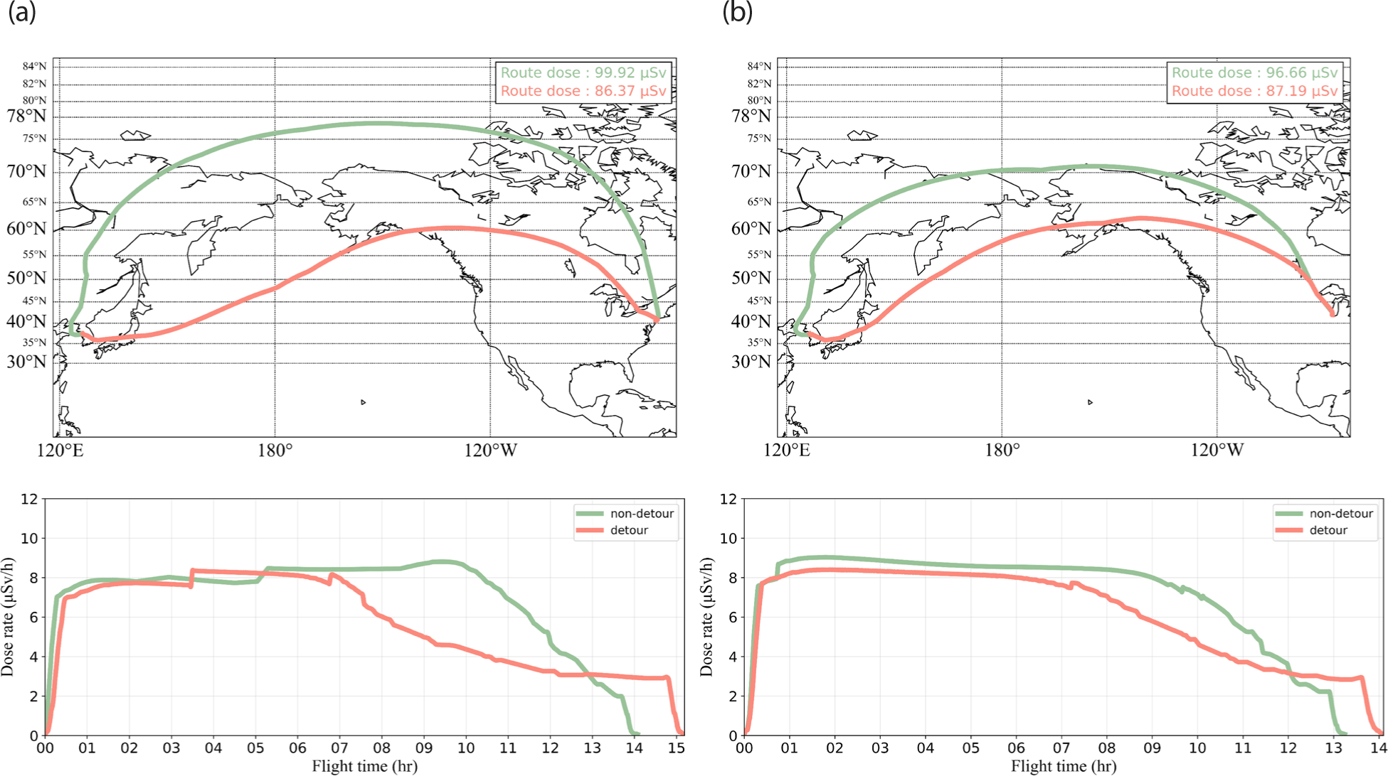
Fig. 4 show the comparative radiation exposure of the North Pacific route with a green line and the Russian detour route with a red line route on September 21, 2021, and September 21, 2022, respectively. In the case from New York John F. Kennedy (JFK) international airport to Incheon (ICN) Airport shown in Fig. 4(a), the exposure route dose of the bypass route (red line) was 86.37 μSv, and the original route of the North Pole route (green line) was 99.92 μSv showing a decrease of 14% route dose. From Chicago O’Hare (ORD) international airport to Incheon Airport, shown in Fig. 4(b), the exposure route dose of the bypass route (red line) was 87.19 μSv, and the original route of the North Pole route (green line) was 96.66 μSv showing a decrease of 10% route dose. As can be seen in the dose rate in Fig. 4(a) and 4(b), the difference in exposure dose according to latitude is not large above about 50 degrees of north latitude, but at lower latitudes below that, the exposure dose was significantly lower than that of the high latitude area.
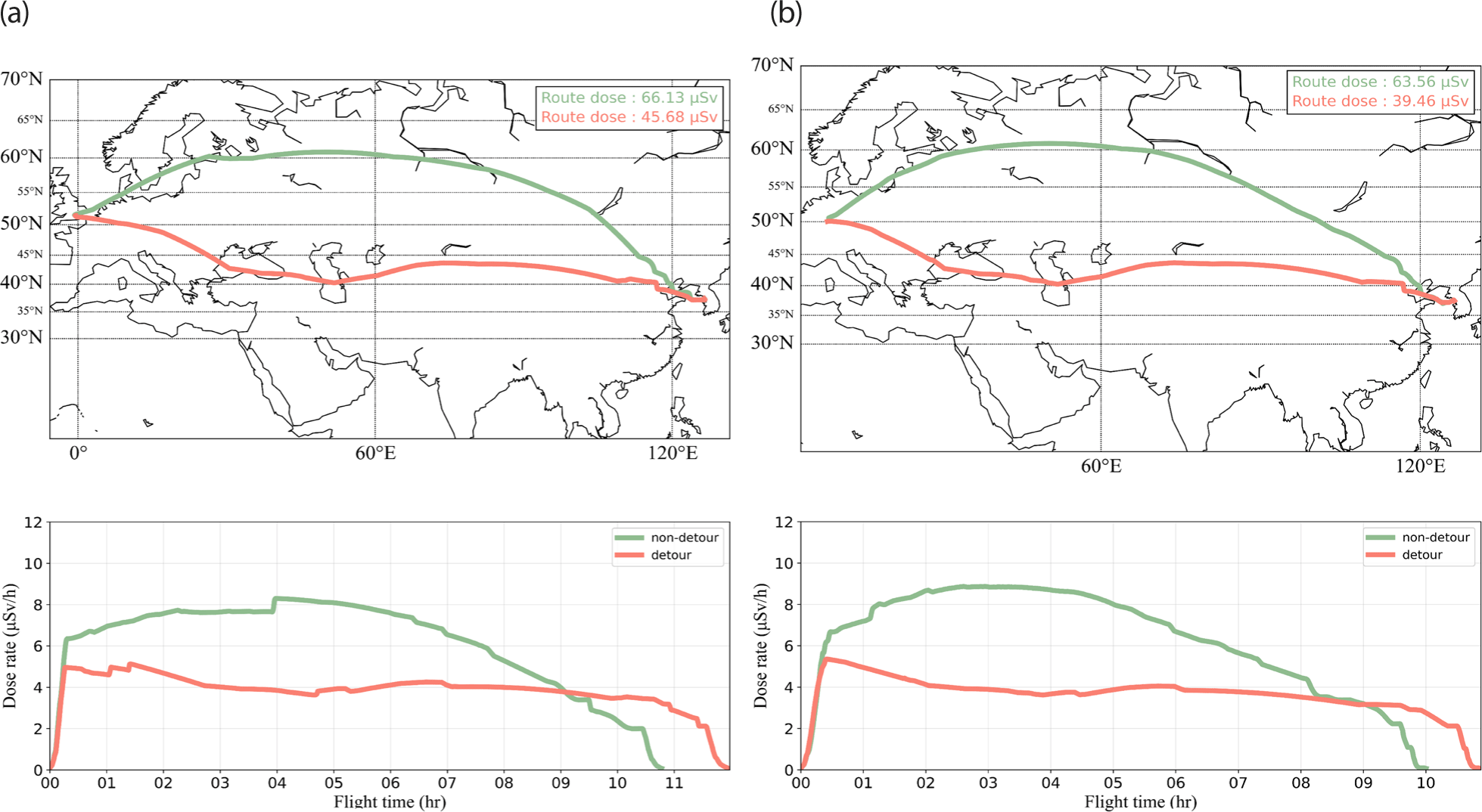
A similar analysis for the European route was performed, and we found the decrease amount is much more significant for European routes. Fig. 5(a) shows the route dose from London Heathrow (LHR) airport to Incheon Airport, and Fig. 5(b) shows the from Frankfurt am Main Airport (FRA) to Incheon Airport. The exposure dose of the bypass route from London to Incheon route was 45.68 μSv, and the exposure dose of the original route passing through Russian airspace was 66.13 μSv showing a decrease of 31% route dose. For the Frankfurt route, the exposure dose of the bypass route was 39.46 μSv, and the exposure dose of the original route was 65.36 μSv showing a decrease of 41% route dose. As can be seen in Fig. 5, in the case of European routes, routes bypassing Russian airspace fly for a longer time at latitudes below 50 degrees north latitude, where the radiation exposure rate varies greatly. In contrast, the original routes usually fly at higher latitudes, and radiation exposure at high latitudes usually is bigger than at lower latitudes. Since the staying time at the lower latitude region was longer, the exposure dose in the detour route was about 20 μSv lower than that of the original route.
4. CONCLUSIONS
Since Russian airspace cannot be used due to the war in Ukraine, most airline companies have been forced to operate detour routes. As a result, airline companies, flight attendants, and passengers suffer from increased flight times. So in this study, we analyzed the actual change in cosmic radiation exposure dose due to the difference in flight time and latitude between the regular and detour routes and found significant differences between the two. For the eastern US routes, the usual and bypass routes operating in high latitudes more than 50 degrees north latitude were not significantly affected by latitude. But it is noticeable that the radiation exposure of bypass routes has decreased somewhat due to an increase in the ratio of flying time in mid-latitude areas. Compared to the US route, where the difference was relatively small, the difference in radiation exposure on the European route was much larger. In European routes, we found that the difference in latitude between the normal route operating in high latitude and the bypass route in mid-latitude significantly affected radiation exposure. As a result, the reduction in radiation exposure due to the operation of the bypass route to Russia on the US East route and the European route was 7.97 μSv and 18.73 μSv on average, respectively.
In conclusion, it is desirable to select an appropriate route according to latitude when allocating the crew’s flight time and schedule since the latitude greatly reduces radiation exposure. We know that the bypass route might cause some reduction in cosmic radiation exposure. In addition, it is expected that solar activity will increase as it is close to the solar maximum period, which is estimated in 2025, so cosmic radiation research in aircraft altitude should be continued.